Showing posts with label KAIRA. Show all posts

Friday, 12 September 2014

KAIRA & Kiitos!

The KAIRA project has been running for some time now and, like most major scientific instruments, there has been a peer-reviewed reference paper produced which describes the facility, its technical capabilities, its scientific goals and the initial results. We have written this paper and it has been accepted by the journal IEEE Transactions on Geoscience and Remote Sensing.


TITLE:     KAIRA: the Kilpisjärvi Atmospheric Imaging Receiver Array -- system overview and first results
ABSTRACT:  The Kilpisjärvi Atmospheric Imaging Receiver Array (KAIRA) is a dual array of omnidirectional VHF radio antennas located near Kilpisjärvi, Finland. It is operated by the Sodankylä Geophysical Observatory. It makes extensive use of the proven LOFAR antenna and digital signal-processing hardware, and can act as a stand-alone passive receiver, as a receiver for the European Incoherent Scatter (EISCAT) very high frequency (VHF) incoherent scatter radar in Tromsø, or for use in conjunction with other Fenno-Scandinavian VHF experiments. In addition to being a powerful observing instrument in its own right, KAIRA will act as a pathfinder for technologies to be used in the planned EISCAT_3D phased-array incoherent scatter radar system and participate in very long baseline interferometry experiments. This paper gives an overview of KAIRA, its principal hardware and software components, and its main science objectives. We demonstrate the applicability of the radio astronomy technology to our geoscience application. Furthermore, we present a selection of results from the commissioning phase of this new radio observatory.
DOI: 10.1109/TGRS.2014.2342252

With the publication of this paper, we regard the build and commissioning phase of the KAIRA facility as being complete. As a result, the time has come to close the KAIRA web log, which was written for the purposes of reporting on the build of the instrument. The first post was written on Wednesday 30-Jun-2010 and, today Friday 12-Sep-12104, we have the last.

To all our readers over the years, thank you so much for your support, comments and attention. It has been great fun writing for you and, as our web counters indicate, it has been very popular. We have covered so many topics, ranging from the technical, to the tragic, to the humerous, and the downright bizarre. And, it has been a tough project, with real blood, sweat and tears. Yet, it has all been worth it.

Even though this web log will now halt, it will remain in place for future reference. For those who still want to read about KAIRA, Sodankylä Geophysical Observatory, and Arctic Finland, the story continues on the SGO web log.


However, we will now close here with thanks. In Finnish, of course...


Kiitos!

Friday, 8 August 2014

KAIRA Lemmings

Lemmings are very common in the Kilpisjärvi area, and they have featured on this blog before. But when we went for a service trip to KAIRA in late June, we took a simple panorama with an iPhone, and then transformed it into a circular, so-called "little planet" panorama – and we were quite surprised by what we found!

Click on the image for higher resolution; you can just make out the KAIRA site in the 4 o'clock and 8 o'clock sectors!

With this image we wish all of you a very good weekend!

Photo and processing: Thomas Ulich (on MiVyoo you'll find the original panorama and details on how it was done).

Wednesday, 6 August 2014

Little KAIRA Planet

Recently, we wrote about how to generate a panorama from 360 images of one degree field of view. However, we can play this game some more. These panoramas are 360°, which means that their outer (left and right) edges match exactly. Therefore, one can use an image manipulation program such as Gimp to create what is knows as "little planet" images. The name stems from the fact that these landscape panoramas are fully encircled by sky and thus look a bit like a planet, alas in the wrong scale.

Here's the little-planet version of the sunny KAIRA panorama, which in addition was rotated in order to have Saana at the top like in the image above. The star-shaped shades are due to the automatic exposure of the GoPro time-lapse camera.

The key ingredient to making these kind of images is Gimp's distortion filter "polar co-ordinates."

Photos and editing: Thomas Ulich.

A related and more explicit description is available on the MiVyoo blog.

Monday, 4 August 2014

KAIRA Egg-Timer Panoramas

Previously, we wrote about a 360° panoramic time-lapse film we made using an egg timer. For the photo above, we wanted to combine all 360 images (one per degree of roation) into one large panorama. This meant to cut from every photo a tiny narrow centre slice and to combine these into one large image. If you look carefully, you can make out the stripes.

On the next day, the weather was much nicer, and we repeated the egg-timer photography. However, due to the GoPro fully automatic exposure settings, and the variable lighting due to fast moving clouds and the bright Sun, it was not possible to make a nice pan-lapse out of these photos, and as you can see, the stripiness is much more pronounced in this image, even though the blue sky is very nice of course.

You can click on the above images to get larger versions.

Original photos and panoramas: Thomas Ulich.

A related article was published on the MiVyoo blog.

Friday, 1 August 2014

KAIRA Pan-Lapse Film

In late June, we visited the KAIRA site in Kilpisjärvi on a maintenance trip. One of many tasks was to repair an HBA cell, which got damaged in a severe storm in spring. Another task was to take lots of high-quality photos of KAIRA and its surroundings for various documentation and illustration purposes.

Right on the first evening, we put a tripod bridging the gap between tiles H57 and H47 on which we mounted a wide-angle GoPro camera, which was glued onto a very cheap and simple egg timer. The egg timer rotates 360° in one hour, and the camera was set to take a photo every 10 seconds, thus taking 360 images, one per degree of rotation.

The full 360° panorama can be assembled by sticking together twelve images, which are five minutes apart. The only problem is to find out how many pixel the image rotates in five minutes, which is 30° of rotation.

The photo above shows such a montage (click to enlarge), featuring the famous mountain of Saana in the sixth pane from the left. Since we have a full rotation, one photo per degree, we can assemble such a panoramic view in 360 different directions, each one showing the a full 360° panorama. Then, we combined them into a short film, giving the impression of full-panorama rotation.

The above explains how we did it, but one can understand what's going on also this way. We generate a time-lapse film from all the images, showing a slow rotation. Then we cut out the centre vertical section equivalent of 30° rotation from this film. Thereafter we glue twelve copies of the very same film side-by-side, but advance the film for each step just the right amount, so that it fits to the previous copy of the film.

We hope you enjoy the result.

We got the idea for these pan-lapse films from Ken Murphy of Murphlab, please visit his site for this and other exciting time-lapse projects.

Photos & pan-lapse: Thomas Ulich.

PS1: You might wonder why we didn't choose a nicer day with more blue sky for this experiment. In fact we did, but due to the GoPro's automatic exposure settings, the large contrasts between looking into the Sun and away from the Sun, paired with shadows of clouds moving across the sky, make the different panes/frames look very different and the result is much less pleasing. So grey skies are good for something!

PS2: Another somewhat more explicit blog post about this went out today on the MiVyoo blog.

Friday, 30 May 2014

Finnish EISCAT campaign, June 2014

A Finnish EISCAT campaign has been scheduled for June 4-10. The campaign objectives are:
  1. Heatncool - D-region ionospheric heating studies by Antti K
  2. Quadriphase-coded experiments - a continuation of the May 2014 campaign! Joint study by Lassi, Björn, Ilkka & Jussi. We also continue the USRP and EISCAT sampling studies, carried out also in May.
  3. TomoScand verification - Ionospheric tomography reconstructions with e-POP satellite mission, joint work with Lassi (SGO) and Johannes Norberg from Finnish Meteorological Institute and a number of collaborating partners from US and Canada, who are involved in the e-POP mission.
  4. EISCAT_3D receiver testing - the objective is to record EISCAT VHF long-pulse-coded experiments in Kilpisjärvi with KAIRA and new receiver technology developed by Siru, Codelma and RF-shamaanit.
Hence a multiobjective EISCAT campaign. I will travel up to Tromsø with Antti on Tuesday June 3 and head back to home around one week later. But in any case, we will try to arrive to Sodankylä prior the Midnight Sun Film Festival. A number of people will be at KAIRA site for all the campaign.

Monday, 12 May 2014

KAIRA Status Map

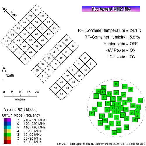
We have a new status map showing the situation with KAIRA.

This shows the actual current status:


This is available from the Status page, which can be found in the title bar of this web log.

The map shows the array layout of the antennas. The High-Band Antenna (HBA) tiles are in the top left and the Low-Band Antenna (LBA) aerials are in the lower right.   The layout is to scale, which is shown, and the direction to the VHF transmitter at Tromsø, is also indicated.

The antennas are numbered and they are also colour coded to show the Receiver Unit (RCU) mode. KAIRA has 96 RCUs and the RCU mode indicates which combination of antenna plus band-pass filter is used for the processing. Sometimes the entire array is configured to a single RCU mode and at other times it is mixed with several different modes for different antennas.

If an antenna is enabled, then the colour is bright, but if it is switched off, then it is dulled down.

In the case of a plain grey antenna icon, this means the antenna is shut down, either for maintenance, or as a result of damage.

Sometimes an antenna might be shaded with two colours like a two-tone maritime-Z-pennant. This is because each antenna has two polarisations, and there will be occasions when the RCU number/status for each polarisation is not the same.

In the bottom left, there is the legend and in the top right is the status label and the current RF-container parameters.

The image at the start of this post is "live". If you update the page, you might see ti change, depending on what KAIRA is doing. But to give an indication of what the status map might look like, here are some other static examples:

A "357"-mode solar observation. The grey antennas
are those knocked out by the March 2014 blizzard.

A mode-3 riometry observation. Storm-damaged antennas
are also present in this particular example.

Wednesday, 16 April 2014

KAIRA -- lyhytdokumentti

Last week we published a film on KAIRA. Today, we have the film again, but with Finnish text/subtitles.


KAIRA on Kilpisjärvelle rakennettu ilmakehän, lähiavaruuden ja syvän avaruuden tutkimukseen tarkoitettu radioteleskooppi. Sen on rakentanut ja sitä operoi Oulun yliopiston Sodankylän geofysiikan observatorion. KAIRA-lyhenne tulee englanninkielisisestä projektinimestä Kilpisjärvi Atmospheric Imaging Receiver Array.

KAIRA-vastaanottimessa on kaksi antennikenttää, joista matalampitaajuinen niin sanottu LBA-kenttä mittaa taajuusalueella 10-90 MHz ja korkeampitaajuinen HBA-kenttä alueella 110-270 MHz. KAIRA voi toimia osana eurooppalaista sirontatutkajärjestelmää EISCATia. Norjan Tromssassa sijaitsee 224 MHz:n VHF-lähetin, jonka ionosfääristä sironnutta signaalia voidaan vastaanottaa Kilpisjärvellä. Lähitulevaisuudessa tulemme rakentamaan osana kansainvälistä yhteistyötä uuden hajautetun sirontatutkajärjestelmän Kalotin alueelle. Tämä projekti kulkee nimellä EISCAT_3D. Siinä tarvittavaa tekniikkaa kehitetään KAIRA-asemalla!

KAIRAn antennikentät on alunperin suunniteltu LOFAR-nimiseen radioastromiaprojektiin. Voimmekin käyttää radioastronomiaan suunniteltuja antenneja ja signaalinkäsittelyä hyvin suoraan ilmakehän ja lähiavaruuden tutkimukseen. Luonnollisesti teemme yhteistyötä useiden LOFAR-asemien kanssa eri radioastronomiaprojektien kanssa.


Tämä lyhytdokumentti kertoo KAIRAn rakentamisesta, asemalla tehtävästä tutkimuksesta ja EISCAT_3D-projektin pitkän tähtäimen näkymistä. KAIRA-aseman rakentamisen on rahoittanut Oulun yliopisto, Euroopan aluekehitysrahasto Lapin liiton kautta ja Sodankylän kunta.

Wednesday, 9 April 2014

KAIRA film


At the LOFAR Science Workshop 2014 in Amsterdam, we premièred the KAIRA film. This was produced by SiteEye in conjunction with Sodankylä Geophysical Observatory, U. Oulu, ASTRON, EISCAT, and many others. (Versions with subtitles in many languages will be posted later.)


Enjoy!


UPDATE!
The film is also available with Finnish subtitles (LINK). 

Tuesday, 15 October 2013

Signing up

You know you've "made it" when you get a Finnish Highway Authority Approved road sign. So, it was with delight that we received ours. You may have noticed it in the photograph as we prepared to head up to the site for the riometry campaign. Well, it's here at KAIRA now and today we feature some of the installation work (which was carried out before the snow set in!).

Unloading the sign posts.

Digging the foundation hole.

Installing the sign.

Hmm... perhaps that foundation hole was a bit deep!

To be continued...

Sunday, 29 September 2013

LOFAR, EISCAT, SKA... and KAIRA of course!

Today's photograph was from the recent science seminar. Here, Prof. Markku Lehtinen explains the major projects and the vital link between them.


The graphic on the slide was one from the early days of the web log. Still as relevant as ever!  :-)

Thursday, 11 July 2013

Another KAIRA map

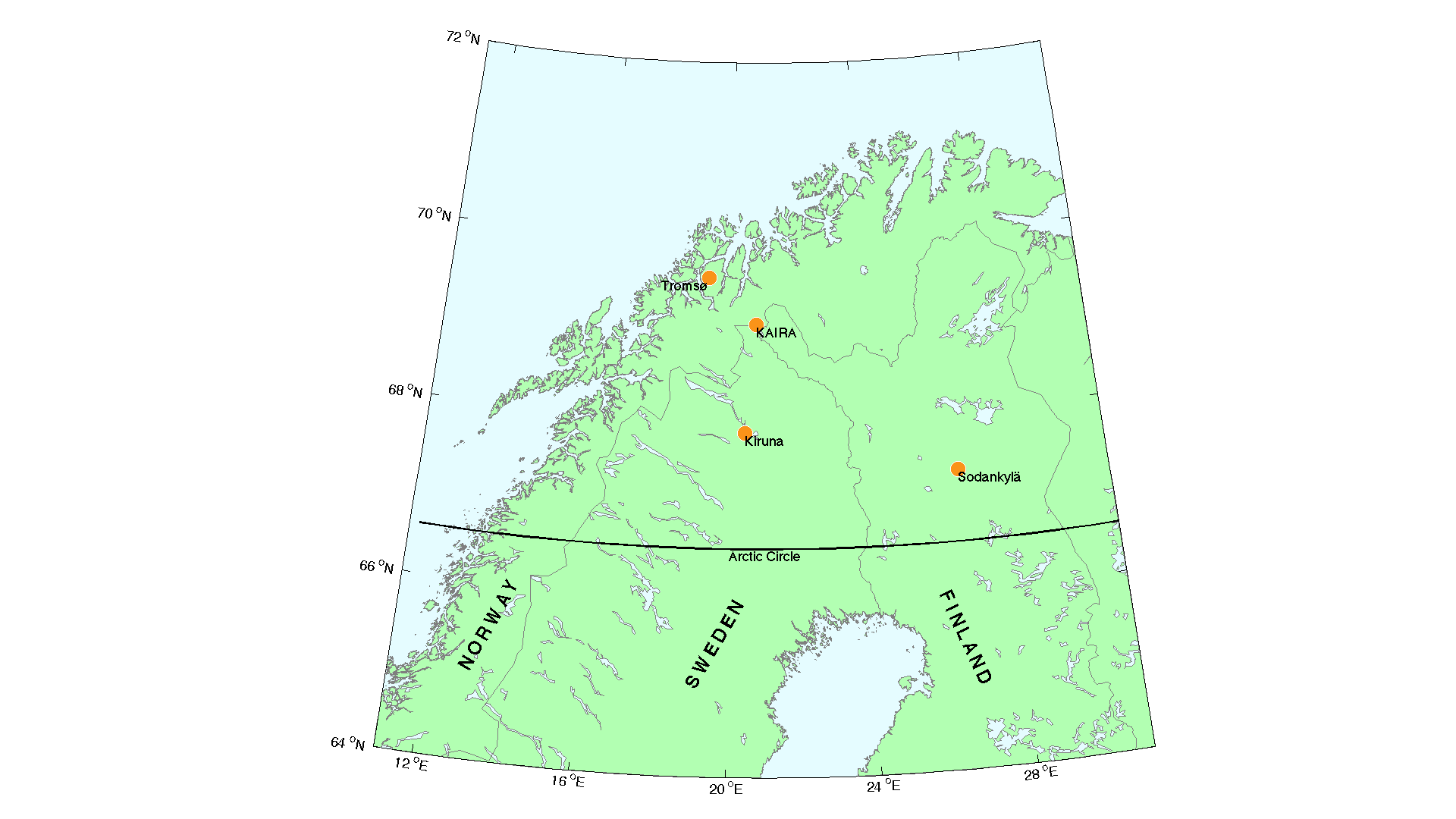
There are one or two KAIRA maps floating about, showing the location of the site with respect to other sites, boundaries and towns. Today we feature a rather nice one, by Thomas Ulich. It is a map of northern Fenno-Scandianvia, showing the location of KAIRA. Also plotted are the locations of the EISCAT mainland facilities.

The direct link to the full version can be found here:

http://www.sgo.fi/KAIRA/press/KAIRA_EISCAT_map.png

Wednesday, 15 May 2013

First VLBI fringes with KAIRA & DE601

On Monday 13th May 2013, a joint test between three LOFAR-based telescopes (DE601, SE607 and KAIRA) was carried out. The target was the pulsar B0809+74. It was a complicated experiment, as there were numerous non-standard procedures in place, a variety of equipment/computing configurations and the challenges of scheduling and data transport. However, DE601 and KAIRA managed to take a short burst of co-temporal data and we managed to get the data from Kilpisjärvi to the correlator in Bonn, Germany.

Then, late last night, we received an e-mail from our German colleagues, with the news that with less than a minute of data, and with only one LOFAR "lane" (that is, a bandwidth of only 12 MHz), they had made a preliminary detection of fringes!

First-fringes! (Image: O.Wucknitz, MPIfR)


As the project coordinator, Olaf Wucknitz, explains...

The plot shows a delay/fringe-rate spectrum for 21.5 sec of the first data block with only lane 0 (12 MHz bandwidth). This is after correction for geometric delay (ca. 0.2 msec). The residual delay is about 0.5 musec, consistent with expectations for the ionosphere. The colour scale is logarithmic.

Note that the signal looks different than for unpulsed sources. For only one pulse we would have a diagonal line because of dispersion. For no dispersion, we would have a vertical line, because one short pulse does not constrain the rate. Dispersion turns this diagonal. Here we have a number of pulses, which causes the maxima at separations of 1/period in rate. This is because a full turn per period could not be detected. Ionospheric rates should be << 1 Hz, so the central peak is the real one.

It must be stressed that this is only a preliminary detection. There is still a lot of work to be done and additional verification experiments need to be carried out before we can proceed with further observational programmes. However, this is an extremely promising result and we are delighted to have made this much progress so far. Apart from advancing towards an exciting long-baseline science programme, we have also resolved numerous technical issues along the way, thus improving procedures, calibration and technique for all our other measurement campaigns.

KAIRA, Kilpisjärvi, Finland (Photo: D. McKay-Bukowski)

DE601, Effelsberg, Germany (Photo: D. McKay-Bukowski)


Of course, this initial detection is the longest baseline to have achieved this within the LOFAR system... a baseline of some 2185 km!

The location of the two stations: KAIRA (Kilpisjärvi, Finland) and DE601 (Effelsberg, Germany).

Thanks go to all the participants in this work, especially to Olaf Wucknitz (MPIfR, Bonn).