Showing posts with label map. Show all posts

Sunday, 16 March 2014

Map of the 2014 KAIRA storm damage

Today, we've plotted where there has been damage to KAIRA. The map is a bit scary, but actually as we have seen from yesterday things are not so bad and we've come out of it fairly well.

As can be seen, we have lost two antennas completely. These are tile #H75 and aerial #L34.

We've had two aerials (#L05 and #L21) seriously damaged. These will need to be replaced.

There are three aerials (#L22, #L35 and #L36) which have been damaged but have been repaired to the point where they are operating normally again. However additional work will be required in the summer when the snow has melted and we can access them properly.

There are many aerials with minor damage. The aerials are still operational, but will require some attention in the summer to ensure they remain robust for the following winter. The problem has been buffeting to the aerial wires causing cracks in the PVC moulding and coatings. These can be patched, but it does require warmer weather.

Thursday, 11 July 2013

Another KAIRA map

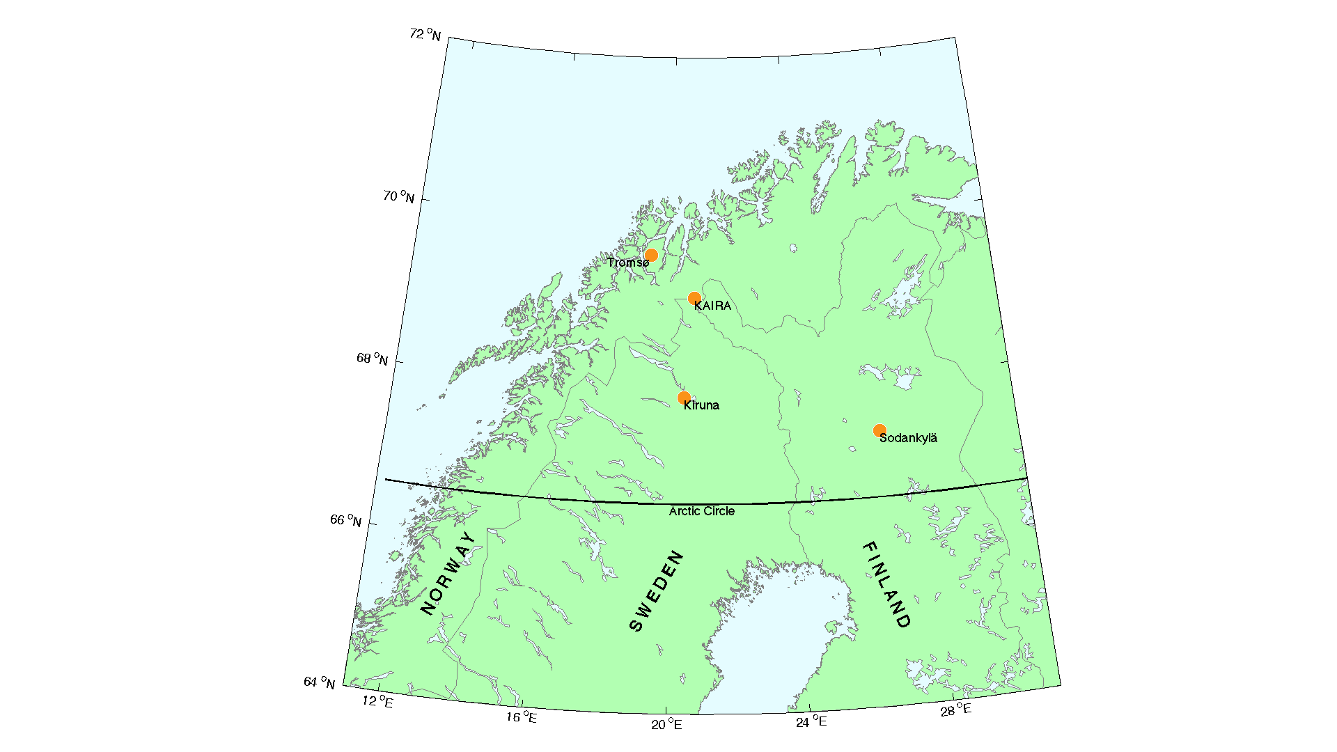
There are one or two KAIRA maps floating about, showing the location of the site with respect to other sites, boundaries and towns. Today we feature a rather nice one, by Thomas Ulich. It is a map of northern Fenno-Scandianvia, showing the location of KAIRA. Also plotted are the locations of the EISCAT mainland facilities.

The direct link to the full version can be found here:

http://www.sgo.fi/KAIRA/press/KAIRA_EISCAT_map.png

Wednesday, 27 April 2011

First LOFAR sites on Google Maps

There's always been some speculation as to which LOFAR stations would appear on the Satellite-view on Google-maps first. Well, it seems that two have made the claim for first place.

DE601 Effelsberg

The Effelsberg LOFAR station is located in North Rhine-Westphalia. The facility is also home to the 100m radio telescope. In the view shown by Google-Maps, the 100m dish is in the north. Below it is the LBA of the LOFAR station (with a zig-zag path running through it). And then, there is the HBA to the south. In the Effelsberg system, the HBA is not in the regular configuration as a conventional international station.


Größere Kartenansicht


DE603 Tautenburg

Tautenburg is a municipality in Thuringia, Germany. It is home to the Karl Schwarzschild Observatory, which is home to the largest optical telescope in Germany (2m mirror). The observatory is set in beautiful forest land. In the satellite image, the LOFAR fields dominate the clearing; the HBA is on the left and the LBA is on the right. The small round building just north of the LOFAR field houses the 2m optical telescope.


Größere Kartenansicht / Enlargement


Although seeing these images on Google-Maps is just a bit of fun, it is useful to see the size of the fields in the context of surrounding structures and the general landscape. A full map showing the location of all the LOFAR stations (excl. KAIRA) is provided on the LOFAR website. Take a look over the next few months and see if you can see any other stations 'appearing' in the satellite images!


Websites

Effelsberg: http://www.mpifr.de/english/radiotelescope/
Tautenburg: http://www.tls-tautenburg.de/research/lofar/index.html
LOFAR map: http://www.astron.nl/~heald/lofarStatusMap.html

Wednesday, 16 March 2011

EISCAT Svalbard Radar — Part 1

If you have looked at the EISCAT map, you will see that we have covered the three mainland sites: Tromsø, Kiruna and Sodankylä. But what of the one to the north?

Yes, EISCAT actually runs a fourth station on the Norwegian-administered archipelago of Svalbard. This is the the EISCAT Svalbard Radar (ESR), located near the settlement of Longyearbyen.

Longyearbyen at midday in late January
2006.
(Photo: Derek McKay-Bukowski)

The ESR system comprises two dishes. One is a fully-steerable 32m dish, which is similar in design to the mainland system. The other is a 42m fixed dish, which is 'field-aligned'. The 'field' in question is the Earth's magnetic field; which arcs out of the magnetic poles. The direction at which the 42m dish is pointing is precisely the same angle at which the magnetic field leaves the Earth's surface.

The two dishes on Svalbard. The fixed 42m is
on the left and the steerable 32m dish is on
the right (Photo: Tony van Eyken, EISCAT)


The 32m dish was built in 1994 and the first observations were taken in 1996. The 42m dish was added in 1999 with observations starting in 2000. The transmitter output can be routed to either antenna as required.

The 32m dish is fully steerable. Despite the 275 ton weight, it can scan at 80 degrees per minute both in azimuth and in elevation and is capable of acceleration from 0 - 100% in 2 seconds.

Friday, 11 February 2011

Where is Kilpisjärvi?

As we've mentioned before, KAIRA will be built at Kilpisjärvi (after all, it's in the name!). However, the Sodankylä Geophysical Observatory is — yes, you guessed it — located in Sodankylä. So, in response to the call for a more enlarged map (compared to our EISCAT/LOFAR/KAIRA overview map), today's web log entry does just that. Zooming in on the Lapland area, both Kilpisjärvi and Sodankylä are clearly marked and show that KAIRA is right there in the corner of Finland, quite a way from SGO.

Kilpisjärvi (Northern Sami: Gilbbesjávri) itself is actually a small settlement in the north-western part of Enontekiö municipality. That small patch of Finnish territory wedged in between Norway and Sweden is known as the Finnish arm of Lapland and Kilpisjärvi is at the end of it. The settlement is quite small, with less than 100 inhabitants. It is an isolated part of the world, with the next nearest settlement over 40 km away.

Still, it is recognisable place, perhaps because of its famous landmark: Saana (Northern Sami: Sána). This fell towers some 556 metres above the nearby Kilpis lake and its summit is a total of 1029 metres above sea-level. It is clearly visible from the KAIRA site as this photograph shows, taken at the end of the 2010 summer, when we did the site survey. It is absolutely clear that many of the best photographs of the KAIRA project that will be posted this year will feature Saana in the background!

At this time of the year however, it breaks through winter’s silent grip on the landscape and stands there as an imposing Arctic sentinel; a natural fortress for trolls, giants and other creatures of Nordic mythology.

I wonder if there are any Sami legends about this beautiful fell?

Wednesday, 2 February 2011

LOFAR

LOFAR (LOw Frequency ARray) is a pan-European radio telescope designed to observe the radio universe at VHF frequencies. It is designed, built and operated by ASTRON, the Netherlands Foundation for Radio Astronomy. The LOFAR system is split across multiple sites — known as stations — each of which typically has two arrays of antennas.

The antennas in each of these two arrays are different in design. One design is a vertical 'aerial' which stands about 1.8 m tall, optimised for radio frequencies in the range 30 to 80 MHz. The other design is a large 'tile', with a square area of 5 × 5 m. It is for the higher frequency range of 120 to 240 MHz.

Did you note the gap from 80 to 120 MHz? LOFAR deliberately avoids these frequencies, as this is where commercial and public FM-radio stations broadcast. There is no point trying to listen for faint cosmic radio signals at the same frequency as a high-powered neighbouring radio station.

In addition to a large cluster of LOFAR stations in the Netherlands, there are additional participants in the main LOFAR project: Germany, France, Sweden and the United Kingdom. This map is a closer view than the one posted earlier, and shows the locations of the LOFAR stations (green = complete, yellow = under construction).


KAIRA makes use of the same antenna technology that is used in LOFAR, making it compatible with the LOFAR system. This opens up some exciting prospects of linking the two projects. We'll be looking at these antenna systems soon.

In addition, there have just been some important achievements by the LOFAR project. More on that in the next post!

Tuesday, 1 February 2011

Putting LOFAR, EISCAT and KAIRA on the map

As one might guess from the name, the Kilpisjärvi Atmospheric Imaging Receiver Array is located in Kilpisjärvi. For those of you who didn't already know, Kilpisjärvi is a small border town located in the top-left-hand corner of Finland. It is usually very easy to find on a map, as it is quite close to the corner of the three countries: Norway, Sweden and Finland.

But possibly less familiar are the related LOFAR and EISCAT projects associated with KAIRA.

This map marks the sites of these project with EISCAT in pale blue and LOFAR in magenta. KAIRA itself is marked in red. At a latitude of +69 degrees north, KAIRA is located well above the Arctic Circle (marked in white), making its association with LOFAR a most northerly one indeed.

There'll be more about LOFAR and EISCAT over the coming weeks, so be sure to visit this weblog again soon.