Friday 30 August 2013

Reindeer at Siilasjärvi

Time for a Friday photograph. This week we have found a rather interesting photo taken by someone other than our own SGO staff. This is wikipedia-user Antti Leppänen, who has taken some excellent photographs of KAIRA and surrounding landscape. There was one in particular that caught our attention. A shot of the KAIRA site from the classic vantage point of nearby Pikku-Malla.

English: KAIRA observatory in Kilpisjärvi, Enontekiö, Finland seen from Pikku-Malla
Suomi: KAIRA-observatorio Enontekiön Kilpisjärvellä nähtynä Pikku-Mallalta
Photograph: Antti Leppänen, 25-Jul-2013. Source: LINK
 Although an excellent photograph, the interesting part is when you zoom in along the shoreline of Siilasjärvi (the lake in the foreground of the image). Look what can be seen there...

Detail from photograph by Antti Leppänen, 25-Jul-2013.
Click on the photo for an enlargement. Source: LINK

If you look carefully, you can see reindeer wandering around on the beach! What an idyllic spot...

Have a nice weekend everyone.

Wednesday 28 August 2013

Passive Radar


Passive radar is a form of radar that utilizes radio transmissions of opportunity as illuminators for targets. Examples of such transmissions are commercial FM radio, GPS signals, TV transmissions, and military radars.

A little while ago, we had several plots showing DAB stations in Norway seen via anomalous propagation at KAIRA. This is a very primitive form of passive radar. A more advanced solution is to measure the transmitted waveform using one receiver, and use this measured waveform when deconvolving the echoes. Today we have some results from FM radio based passive radar operating at the MIT Haystack Observatory using two dipole antennas and a USRP N200. The plots were made while commissioning a new 16-channel USRP based system called MIDAS-Mini, which will eventually replace older ISIS Echotek digital receivers used for this same purpose.

The concept of passive radar is not that new. For example, the Manastach Ridge Radar or the Haystack Observatory ISIS system can be used to observe specular meteor trails, ionospheric E-region irregularities and E-region drift velocities -- but only using commercial FM radio transmitters and relatively cheap hardware. To read more on the topic, refer to eg., Frank Lind's Ph.D. thesis.

In the video above, you can see airplanes with time variable Doppler shifts flying around the Boston and Rhode Island. This was recorded using a USRP N200 with one yagi antenna pointing towards the transmitter and another antenna pointing towards the opposite direction.

Tuesday 27 August 2013

The Rawlings Array

As reported on the LOFAR-UK web log today, on Tuesday 27th August, the LOFAR station UK608 at Chilbolton in the United Kingdom was renamed as "The Rawlings Array", in honour of Professor Steven Rawlings.

The plaque unveiled in honour of Professor Steve Rawlings. Reflected
off the surface of the plaque is the 25m Chilbolton dish. (Photo: A. Mallet)


Professor Rawlings passed away in January 2012. Before his untimely death he was the Head of Astrophysics at Oxford University. He was a leading member of the LOFAR-UK community and played a major role in the construction of the UK LOFAR station during the critical build phase. He was a driving force of many other international projects, not just those in Great Britain, and was an outstanding leader and mentor to his staff and students.


The RF-container at the Rawlings Array. The new plaque is in the centre
of the container side. In the background is the LBA array (Photo: A.Mallet)


The dedication ceremony at Chilbolton Observatory was attended by members of his family and members of the LOFAR-UK and international scientific communities.

Monday 26 August 2013

Jicamarca Radio Observatory

Jicamarca can only fit in a picture when photographed from one of mountains around the observatory. The view  is dominated by the 300x300 49.92 MHz 3 MW incoherent scatter radar that is the largest in the world in terms of size. One can also see the SOUSY radar on the bottom center. 
Peru is one of the most unlikely world super powers of radar. This is largely due to the fact that the Jicamarca Radio Observatory was established there in the early 60s at the outskirts of Lima. Even though the radar has some rust on it, it is still one of the most capable and flexible incoherent scatter radars in the world. Jicamarca is kind of like LOFAR and KAIRA-- a radio science playground. The radar and various transmitters and antennas at the observatory can be mixed and matched on very many different ways to implement many completely different remote sensing experiments. Many new radar methods used now all around the world have also been developed at the observatory.

One special feature of the radar is that is resides at the geomagnetic equator. Due to the narrow incoherent scatter spectrum when viewed with a 90 degree aspect angle to the magnetic field, the radar can be used to measure very precise East-West drift velocities.  Other special features of the radar are interferometric imaging of perpendicular to the magnetic field ionospheric irregularities, interferometric angle of arrival determination of meteors, and absolute calibration of electron density using Faraday rotation from two different characteristic propagation modes of radio waves in the ionosphere. 

It is impossible to go through all the capabilities, science, and history behind this wonderful instrument. The best that I can do is refer to the list of publications related with the observatory.
A view of the main JRO radar (background) from the SOUSY radar (foreground).

The mattress antennas in the foreground, and the digisonde transmitter antenna in the background. Tilted 50 MHz Yagi antennas can also be seen. If you look carefully, you can also see some AMISR panels too. Finally, there is the 4 MW 50 MHz dipole. A story tells that a bird once landed on it while it was hot. The witnesses say that the when the bird flew off, it seemed to be unharmed, until a few seconds later it suddenly just stopped flying and fell to the ground.


Inverse Days 2013 - Registration is open

The annual Inverse Days of the Finnish Inverse Problems Society will be held in Inari 11-13 December 2013. The venue is the Sami cultural centre Sajos.

Registration is now open! For details, see www.inverse-problems.org/id2013.

Winter scenery on Lake Inari.

Sunday 25 August 2013

Esa Turunen appears in Lapin Kansa

Hey! Look who turned up on the Lapin Kansa newspaper yesterday... Director of Sodankylä Geophysical Observatory, Esa Turunen!


The cause for the article is that the observatory is celebrating its 100th anniversary next month. No doubt we'll be posting lots about that in the near future.

Saturday 24 August 2013

Ionospheric Tomography Receiver - Bits and Pieces

Today we shipped the 6th TomoScand tomography receiver to Helsinki for some more detailed testing prior to shipping to Svalbard. We started the day by dismantling the  GPS mushroom:

This small mushroom-shaped object is a GPS antenna meant for time stamping beacon receiver signals. 
Other items to be shipped are the USRP, front-end and computer...
This hassle is a test set-up of the usrp + computer and some other electronics stuff. Merely for testing at a certain point...
Ok, this looks weird... The beacon receiver helix antenna is inside the blue radome (i.e. inside the buckets). The antenna is meant for 400 and 150 MHz beacon carrier wave signals.
and from here we took only the preamplifier... . 

And thus we had all the electronics

Here we have packed nearly all the receiver item for the Svalbard tomo receiver.
Here are all the necessary items of the Svalbard tomo receiver. Thus we need to send all these items to FMI Helsinki.
Here all the items are in SGO&FMI main building Polaria. 
And here everything is nicely packed and we can post it to Helsinki.... Thus from now on our tomography main master will do all the practical details!
And here everything is packed and ready to go to FMI Helsinki for further testing!

Friday 23 August 2013

New ionospheric tomography station - Longyearbyen, Svalbard

The sixth receiver of the TomoScand network of the Finnish Meteorological Institute will be installed in Longyearbyen, Svalbard, Norway, in September. Expedition preparation commenced early August by testing the receiver at SGO. Today we will send the instrument to Helsinki for further testing. Expedition to Svalbard will commence September 12 with a return flight five days later. Instrument will be installed in the Kjell Henriksen Observatory.

The total number of FMI & SGO ionospheric tomography receivers will be 11 after the (hopefully) successful expedition to Svalbard! Detailed info on the technology of the tomography receiver at Jitter website http://www.sgo.fi/~j/jitter/web/!

TomoScand and SGO tomography receivers with the new Longyearbyen station (LYR). Map also shows the  IMAGE magnetometer network station locations.


Thursday 22 August 2013

ISR Radar School 2014

I has been announced that the 2014 Incoherent Scatter Radar School will be held at the Arecibo Radio Observatory in Puerto Rico. This will be a joint event between the European and United States radar communities.

Arecibo Radio Observatory (Soruce: PD-USGOV-DOC-NOAA/Wikipedia)

The Arecibo Radio Telescope is a most distinctive facility, owing to its unusual design and huge size. It is build into the landscape, using the natural shape of the terrain to assist in the forming of the main reflector. This is fixed, and provides a limited view of the sky overhead. However a moveable gregorian secondary focus allows some degree of flexibility. That, and the earth's natural rotation, allow it to observe a narrow band of the sky between Declinations -1 and +38 degrees.

It is also extremely large. The 305-metre diameter means a total collecting area of 73,000 square metres... this holds the record for the largest physical size of any radio receiving system ever since its completion in 1963. And although it will be exceeded in the near future by other telescopes that are under construction (e.g. when finished, the LOFAR HBA will be 76,000 m2 and FAST will be 196,000 m2) and those that are planned (such as SKA and  KARST), the Arecibo Radio Telescope will remain an important and powerful scientific instrument for many years to come.

Links:

Wednesday 21 August 2013

Minicourse on Spatial Models

We organised a two-day minicourse (or actually three-day event for some participants) on spatial models and related issues in Math Department in the main campus of the University of Oulu. Lecturer Finn Lindgren (University of Bath, UK) presented studies on Gaussian Markov random fields as well as the R-INLA software, which is a computational solution for studying GMRF and other similar models.

We started on Monday by a splinter session on Gaussian Markov fields and gave a special emphasis on the boundary conditions.
Sari Lasanen discussing convergence issues.

On Tuesday Finn Lindgren gave talks on stochastic partial differential equations and on the R-INLA software itself.

Finn Lindgren talking about the R-INLA package.
Naturally blackboard is a handy tool for writing down the most important equations! (Why are the blackboards so rare in the commercial lecture halls nowadays?)

Of course we had to define stationary random fields.

Wednesday ended with hands-on exercises on R-INLA (for details, see r-inla.org). Afterwards we had several science discussions before lecturer and some of the participants had to take the flight/train to various destinations. For us, it meant of course a drive up to north to the Observatory in Sodankylä!


More info on the event at inverse-problems.org/gmrf2013.

Tutorials and lab exercises at http://people.bath.ac.uk/fl353/tutorials/oulu/.

Monday 19 August 2013

100000 pageviews for the blog!

Blogger statistics look like this when we cross the 100k boundary. 
We just crossed a significant milestone for the blog when we reached 100000 pageviews. Thank you for everyone who has made this possible.

If you are wondering what the spike in February is, it corresponds to the flyby of the asteroid 2012 DA14 and the Chelyabinsk meteor. We were measuring the asteroid, and by coincidence there was the Chelyabinsk meteor event. Naturally, the media started asking us if these two are related, and therefore Derek McKay-Bukowski looked at the dash cam footage and determined an approximate radiant of the Chelyabinsk meteor. He quickly concluded that they weren't related. This was linked to many places and all of the sudden, our traffic exploded.

Next up, 1 million pageviews. 

Sunshine in the data

'Tis "Data Monday" again. Today, we've an example of where the radio-bright sun is showing up in one of the all-sky images.


Click on the plot to enlarge it.Note that this is an orthographic projection. Also, this is a "sky-view"... in other words, it is as if you are lying on your back in the middle of the array looking up. A few markers indicate some bright sources (Cas A and Cyg A) and directions (such as the direction to the VHF transmitter in Tromsø).

However, the one to look for is the very bright object at the bottom of the plot: radio emission from the sun.

Sunday 18 August 2013

EISCAT symposium banquet

Today we have the last entry from the EISCAT International Symposium. On Thursday evening, we had a banquet at the magnificent Lancaster Town Hall at Dalton Square. There is a post and some more photographs of the event at the EISCAT_3D web log.

Arriving at the conference dinner. (Photo: Th. Ulich)

The evening included some musical entertainment as well. There was an impressive recital given on the pipe organ and the courses of the sumptuous meal were punctuated by the enchanting music of the Tempest Flute Trio.

Saturday 17 August 2013

More conference outing photographs

Having taken the M/V Swan across Windermere, we then alighted to catch a steam train from Lakeside up to Haverthwaite.

Steam locomotive "Repulse" pulls in to lakeside railway station.

Alighting the train at Haverthwaite.


Note: there was a discussion about the "thwaite" part of the name Haverthwaite. Apparently it is, as we guessed, of norse origin. It comes from þveit meaning a clearing or open space of land.

Friday 16 August 2013

Conference outing photographs

Friday photos... today we have some photographs from the conference outing. As scientists, we rarely get out, so the conference organisers were kind enough to take us on a quick tour to see the local landscape. Of course we continued to discuss science, results, data, experiments, etc. during the trip, but it was a chance to get some fresh air and see the outside world!

The tour took us on the motor vessel "Swan" across Windermere (which is a mere, not a lake!)


At the pier

M/V Swan pulls in.

Heading out

Nearly at Lakeside

Thursday 15 August 2013

EISCAT 2013 conference photo

Today's photograph is the conference photograph from the EISCAT 2013 International Symposium.


The conference is still in progress (until Friday), and today there will be a number of KAIRA talks.

Website:   http://eiscat2013.lancs.ac.uk/

Wednesday 14 August 2013

DistroAstro


Many astronomers use Linux. It is a powerful, portable and open operating system that is readily available (i.e. free and runs on most hardware). The KAIRA software (from the control system through to the data reduction) runs on a Linux system. However, Linux is also an interesting choice for general astronomy users.

Now, there is a Linux "distro" (= distribution) specifically tailored to the astronomy enthusiast. It is called "AstroDistro" and is available from http://www.distroastro.org/ . The latest release has just been made (v1.0.2, 09-Aug-2013) and details can be found on the web site.

Even if you don't install it, it is useful to whip through the slideshow presentation and see what sorts of interesting software can be run on Linux (not just AstroDistro, but many other distributions as well).

Tuesday 13 August 2013

EISCAT 2013 underway

This week we are having the EISCAT International Symposium at Lancaster University in the United Kingdom. Today's photograph was taken by Thomas Ulich, who made this panorama of the participants just as the conference was getting started. Although it has been posted already on the E3D weblog, it is such a great shot that we asked it we could put it here too!


EISCAT 2013 International Symposium (Photo: Th. Ulich)

The speaker at that particular moment was Craig Heinselman (EISCAT Director) who was giving the introduction presentation.

You can follow the progress here on the EISCAT_3D web log, on the EISCAT_3D Facebook page, as well as on three different Twitter feeds: @EISCAT_3D, @EISCATUK and our own @KairaProject.

Monday 12 August 2013

Answer to the strange RFI

Data Monday again... so what was the answer to the strange RFI we reported a couple of weeks ago? Well, the best suggested we've had, is that it is Digital Audio Broadcast (DAB) radio from Norway. As each Each DAB multiplex has a bandwidth of about 1.536 MHz, that matches what we see in the data quite nicely. The propagation is probably via anomalous behaviour in the ionosphere (such as sporadic-E-layer).


The Tromsø transmitter is at 225.6 MHz and the Norwegian national transmitter is 229.07 MHz.
Regional
Region: Nordland og Troms, Nordland og Troms
Transmitted on: Band III - 12B - 225.648MHz - (Nordland og Troms)

National
Norge Riks
Transmitted on: Band III - 12D - 229.072MHz

Reference: http://www.worlddab.org/country_information_/norway/multiplexes

Thanks to Juha Vierinen for finding these!

Sunday 11 August 2013

EISCAT workshop 2013


Starting with the reception this evening, we have the EISCAT International Symposium 2013, which is being held in Lancaster, United Kingdom (although after yesterday's post we'll need to double check that!). The EISCAT Scientific Association is an international research organisation operating three incoherent scatter radar systems, at 931 MHz, 224 MHz and 500 MHz, in Northern Scandinavia. It is funded and operated by research councils of Norway, Sweden, Finland, Japan, China and the United Kingdom — collectively, the EISCAT Associates. The EISCAT Associates organise a biennial scientific symposium and this year's is being held in the UK at Lancaster University.

There are three presentations about KAIRA...


... and one special presentation:


However, there will be lots of talks related to the fields of research that KAIRA is used to investigate and an excellent selection of astrophysical and geophysical results. In additional to our regular articles, we will be reporting on this important meeting during the week and posting about it via Twitter (@KairaProject)

Website:  http://eiscat2013.lancs.ac.uk/

Saturday 10 August 2013

Manchester Hauptbahnhof

He thought he was going to England...

Next week, there is the EISCAT 2013 International Symposium, which is being held in Lancaster, United Kingdom. Our KAIRA project will be well-represented there, with a number of talks being given... more on that later. Also, one of our regular web log contributors will be there too and, like most of us, will be travelling this weekend. However, what was somewhat perplexing was when the tickets arrived at the observatory for him they were from Deutsche Bahn and in German:

Bitte einsteigen! (Klicken Sie um das Bild zu vergrößern)
We think the destinations are correct (or is there a Manchester in Germany somewhere)? Or did they think that Sodankylä is in Lichtenstein? Or that Herr Roininen is from Austria? Has DB (Deutsche Bahn) taken over the running of the British railway network?

Hopefully it just means that the trains will run on time!


Friday 9 August 2013

Viiankijärvi

It is Friday again and thus time for a nice photograph to end the week. Today's photograph is of the lake Viiankijärvi, which is in a nature reserve to the north of Sodankylä. Very scenic, although there were a few mosquitoes too...

Viiankijärvi (click to enlarge)

Have a nice weekend, everyone!

Thursday 8 August 2013

Polyphase-coded incoherent scatter measurements at Millstone Hill


In 2012 we carried out a joint project with our MIT colleagues at Millstone Hill and tried a set of different polyphase codes. The results are now reported in our joint paper, which has been accepted for publication in Radio Science:

Reference: I. I. Virtanen, F. D. Lind, L. Roininen, P. J. Erickson, W. C. Rideout, M. Orispää, J. Vierinen and M. Lehtinen, Polyphase-coded incoherent scatter measurements at Millstone Hill, Radio Science (accepted 4 Aug 2013).

Abstract: We report first results of polyphase-coded incoherent scatter measurements at Millstone Hill. To our knowledge, these are the first incoherent scatter measurements with polyphase alternating codes of Markkanen et al. (2008) and optimal quadriphase sequences of Damtie et al. (2008). The results demonstrate that an arbitrary waveform generator recently installed at the Millstone Hill incoherent scatter radar, part of the NSF Geospace Facility operated by the MIT Haystack Observatory, is capable of reproducing the polyphase waveforms with an accuracy sufficient for incoherent scatter measurements. Polyphase codes will allow incoherent scatter radar experiments to be better optimized, because they provide a larger variety of code and code cycle lengths than the traditional binary codes.

An early access version is available online at http://onlinelibrary.wiley.com/doi/10.1002/rds.20058/abstract.


The MIT Millstone Hill incoherent scatter radars.


The repair in the data

Over the last few days, we've been reporting on the damage and repair work to KAIRA LBA aerial L17. This story started with the data and so that's how we'll end it. The image for today is the data trace from the day of the repair. Yes, the data acquisition was running throughout this time, so it is possible to see (in the radio spectrum) the repair taking place.


If you look carefully, you can see distortions in the data in data after the point when the aerial was re-erected. This was due me being right next to the aerial during that time as I attached the nylon line and O-ring and then did up the knots and attach the cable ties. In total the whole process took about 5 minutes... excluding the time before re-righting the aerial, as I prepared the various items.

What this does show, though, is that people walking around the aerials do make a difference! Thus wandering on to the field during observations is not without consequence.

However, more significantly for us is that the discovery and repair were made on the 1st August... over a month since the aerial fell. Of course one aerial in 48 is not going to be a dramatic effect in the beamformed data, which is what we normally look at, but still it is a concern that we didn't notice this earlier.

While there are some procedures that exist for the main LOFAR network to test data integrity, they are not really suitable for the operations at KAIRA. However, we are now devising some new software to allow us to easily and automatically monitor the individual RCU data and thus hopefully detect such problems if they occur in the future.


Wednesday 7 August 2013

LBA repair work

Yesterday we showed the fallen LBA aerial #L17... the cause the mysterious step function in the data.The break itself had occurred in the elastic at the base of the northwest line. Subsequent examination suggests that this was premature deterioration (although an alternate hypothesis blames lemporidae).

Of course, upon discovering the problem, the aerial was quickly repaired. Without the exact replacement part, we had to improvise. And the photographs today show what we did.

The O-ring connects the line to the peg. Some degree of elasticity is required, as tension and flexibility are required... especially as ground movement can occur during the freeze/thaw cycle. The knot is a clove hitch and three half hitches. The line then goes back to the top. (Photo: D. McKay-Bukowski)

At the top, a knot connects the nylon to the dipole wire. Three cable ties and a fold back hold the remainder of the nylon line to provide two securing points and keep it neat. (Photo: D. McKay-Bukowski)

The repaired LBA aerial (Photo: D. McKay-Bukowski)


Tuesday 6 August 2013

Fallen LBA aerial

Yesterday, we showed some subband statistics data that indicated that something had gone awry with RCU 034 and 035. Of course a LOFAR expert would recognise that these are adjacent RCUs, and thus pertain to the same antenna. Knowing the KAIRA system (or making an educated guess) you could tell that this was antenna 17. Furthermore the peak at around 60 MHz (and the fact that the frequency range was 0–100 MHz) meant that this was an LBA unit.

The next hint, was that RCU 035 took 3 seconds to fail but RCU 034 took only 1 second, starting a second after the first. This indicates a failure on the Y-polarisation first, and implies that this first failure on Y, led to the failure on X. Sure enough, that was indeed the cause.

Here is what we found on arrival at the site.

Luckily the wires were not damaged on the peg! (Photo: D. McKay-Bukowski)

As the data suggests, one of the guys broke causing the aerial to fall. The first second would have the northwest line (the Y-polarisation with elastic) drop down. At this instance the X-polarisation is still intact. Then, without tension on the northwest axis, the antenna begins to fall. As it reaches the ground the X-polarisation deteriorates rapidly. That is why there was a difference in timing of the failure. Also, from initial break, to hitting the ground, the fall took approx. 3 seconds. It was probably assisted by the wind.


The fallen LBA aerial. (Photo: D. McKay-Bukowski)

Monday 5 August 2013

Another data puzzle

Strangely, we have some interesting data to show up again today. It must be Monday! Curiously, we always seem to find interesting data to show on a Monday. I think it must be because the weekend are the only two work days when you can really concentrate on careful scientific analysis. There's almost an unwritten code that says "Week-end: Scientist at Work... do not disturb".

Anyway, today's interesting data was discovered in a sort of backwards way. We found out the source first, and then went back into the data to see the effect. However, for the purposes of making an entertaining web log (sic) we are presenting it the other way around.

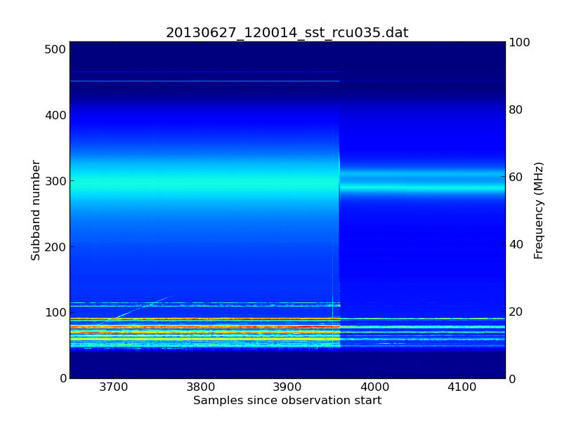
So, starting at 13:06:12 UTC on 27th June 2013, something very strange happened in the data stream on RCU 035.

A strange change in the signal level (click to enlarge).


The above spectrogramme is plotted from a single subband statistics (SST) file. The horizontal axis is time and the vertical axis is frequency. The jet colour scheme shows the log of the received power (dark blue is weak; light blue is stronger).

The transition between the working and failed states took approximately 3 seconds.

We saw the same effect in RCU 034 as well, although here the transition was a bit faster (the data remained good for the first second as RCU 035 was deteriorating and then it changed rapidly to give the same end effect). However, there was no change in any of the other 94 RCU channels.

So, all you LOFAR experts out there... can you tell what caused this abrupt step function in the data?

Sunday 4 August 2013

Hydrogen Maser

Hydrogen maser at the Westford Radio telescope. 
Hydrogen masers are the gold standard of stable clocks. Their frequency is derived from the spin-state transition of the electron of a hydrogen atom, which is corresponds to an emission at 1,420,405,751.786 Hz. This clock is very stable on the time scale less than or equal to a day. The Allan standard deviation deviation (standard deviation of the frequency error) on the scale of hours can be 10^-15.

The clock shown above is located at the MIT Haystack Observatory and used as the frequency standard for the 20 GHz Westford Radio telescope that is used for very long baseline geodesic measurements, ie., measurements of the drifts of the continents and the Earth's orbital parameters using radio stars as references. 

Friday 2 August 2013

More summer storms

Down came the rain...

When those summer thunder storms come through, the certainly make themselves noticed. Here are some photographs from a recent storm that swept through the SGO site at Tähtelä. It probably only lasted 15 minutes or so, but the deluge was most spectacular.

Torrential downpour by the EISCAT 32m dish at SGO (Photo: D. McKay-Bukowski)

The rapidly flooding carpark as the rain hammered down (Photo: D. McKay-Bukowski)

Thursday 1 August 2013

Astropy python library


In the past week, the main reference paper for the Astropy programming toolkit has been released. Quoting from that paper:


The Python programming language has become one of the fastest-growing programming languages in the astronomy community in the last decade. While there have been a number of efforts to develop Python packages for astronomy-specific functionality, these efforts have been fragmented, and several dozens of packages have been developed across the community with little or no coordination. This has led to duplication and a lack of homogeneity across packages, making it difficult for users to install all the required packages needed in an astronomer's toolkit. Because a number of these packages depend on individual or small groups of developers, packages are sometimes no longer maintained, or simply become unavailable, which is detrimental to long-term research and reproducibility.

Motivated by these issues, the Astropy project was started in 2011 out of a desire to bring together developers across the field of astronomy in order to coordinate the development of a common set of Python tools for astronomers and simplify the landscape of available packages. One of the primary aims of the Astropy project is to develop a core astropy package that covers much of the astronomy-specific functionality needed by researchers, complementing more general scienti c packages such as NumPy and SciPy, which are invaluable for numerical array-based calculations and more general scientific algorithms (e.g. interpolation, integration, clustering).

{Astropy}... covers units and unit conversions, absolute dates and times, celestial coordinates, tabular and gridded data, common astronomical file formats world coordinate system transformations, and cosmological utilities


More information can be found on the Astropy website: http://www.astropy.org/

Or from the reference paper itself: http://arxiv.org/abs/1307.6212